The Pallikaranai Wetland came into existence as a salt marsh created by the backwaters of the Bay of Bengal. The following series of mapping represent the morphology of Pallikaranai Wetland located in the city of Chennai, Tamil Nadu.
Mapping the fragile ecosystem of Pallikaranai Wetland, Chennai
As a part of elective – Food and the city, CEPT University
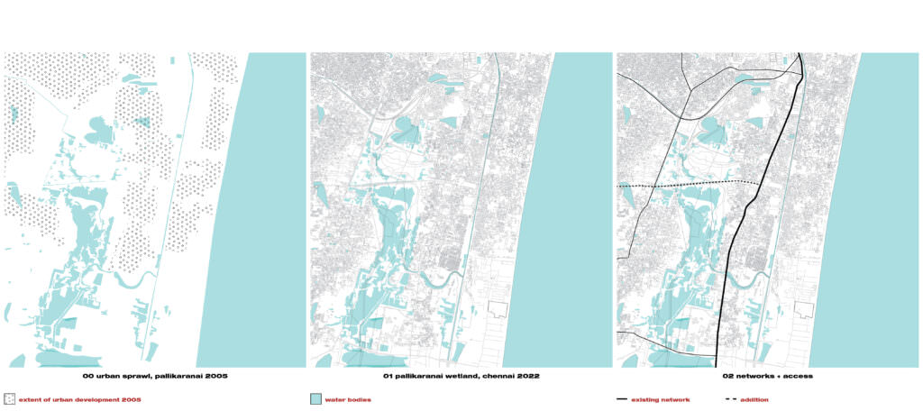
Over the years, the land use that has changed in the suburban areas of Chennai are due to the conversion of agricultural and wastelands into IT, industries and settlement expansion. The once 5000 ha marsh had lost around 90% of its original extent and was effectively spread only around 593 ha. Urban development has taken place in ecologically sensitive zones. The environmental changes that have taken place in Pallikaranai marsh until the year 2001 are extreme progression of urbanization dynamics which have have a dramatic influence on the ecosystem marshland. The water spread area of Pallikaranai has reduced from 33 sqkm to 22.247 sqkm. The total loss in water spread area in between 1975 and 2008 is 10.753 sqkm.
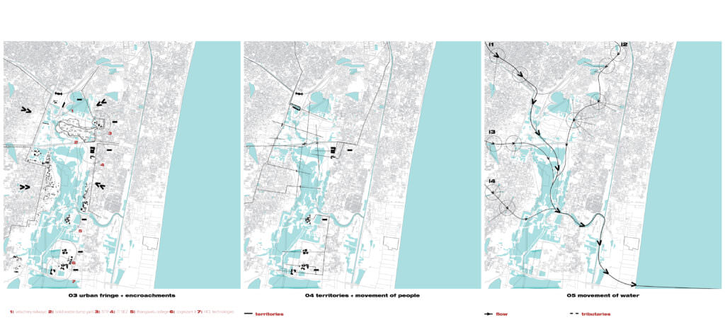
The pallikaranai marsh is situated adjacent to Velachery, also known as Vedashreni a rapidly developing urban area in the Southwest of Chennai. Surplus water from the 31 tanks situated in three directions namely north, west and south of the wetland drains into the marsh, flows through Okkium Maduvu into the Buckingham Canal and drains into the Bay of Bengal near Muttukadu Creek. There are 4 major inlets to the wetland namely i1- Pallikaranai; i2- Narayanapuram; i3- Madipakkam – Velachery; i4- Taramani – Perungudi. The slope is toward the south and it drains the water from the northern side in Velachery and the hills on the west and southwest of Nanmangalam, Pallavaram and St. Thomas Mount toward the southern extremes, finally finding way to the sea via the Kovalam creek.
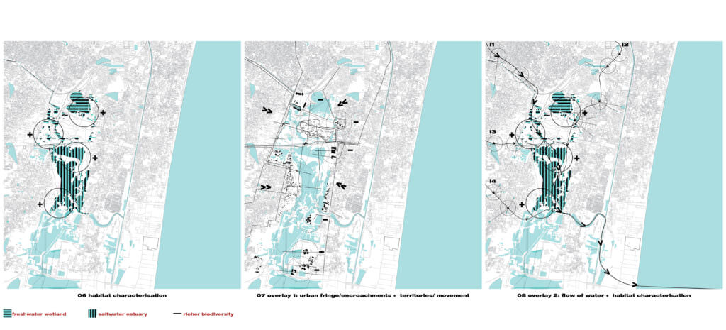
The Pallikaranai marsh is divided into two distinct portions by the KT link road which is becoming a dense traffic corridor. The road practically cuts off the continuity of the wetland system. Due to the formation of a solid boundary, the water movement between the two segments of the marsh is stopped. Thus there are hinderances in the movement of aquatic species, water birds, reptiles and amphibians across the wetland. There is also high accumulation of pathogenic organisms. The northern part of the wetland primarily functions as a freshwater wetland whereas the southern part functions as a saltwater or brackish estuary. It has been studied that the marshland is home to more than 60 species of plants, 45 species of fishes, 100 species of birds, 7 species of butterflies, 20 species of reptiles, 9 species of amphibians and several species of molluscs and crustaceans. These wetlands serve as an ideal habitat for a diverse variety of species becasue of their water ecosystems and also Typha, a tall grass which provides protection and habitat.
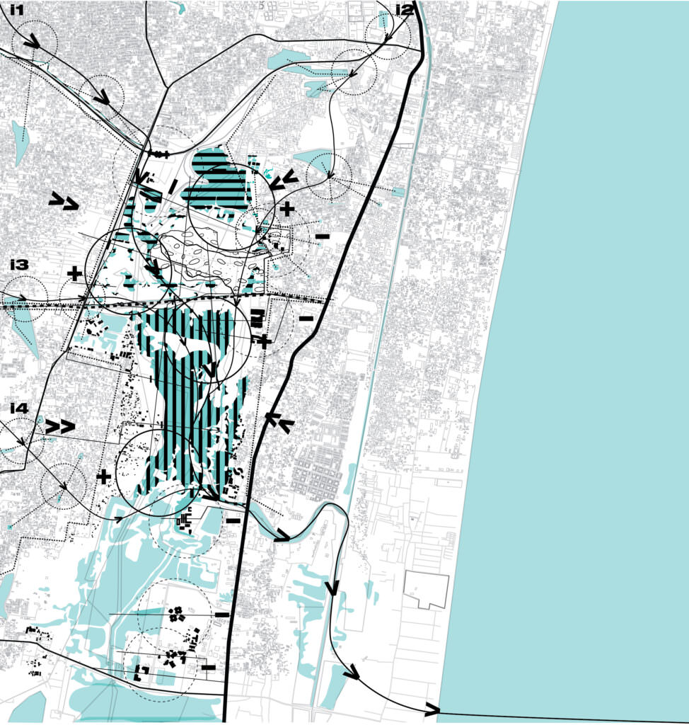
This map is a consolidated overlay of all the previous map to understand the history, functioning and ecological importance of the Pallikaranai marshland.
The flooding in Chennai has been getting worse since the encroachment of low lying areas.
What would be the scenario if Pallikaranai is completely destroyed or urbanized at one point of time? How drastically would it affect the ecosystem?
What should be the strategy at various scales (i.e authorities, planners, environmentalists and citizens) to protect and preserve Pallikaranai?


