

Hence, the project ‘str-EATS’ reimagines ROWs in a productive way by integrating edible gardens, water swales, and green corridors with native species into the overall design. The larger idea is to activate streets, create new programs, and create spaces for city residents. Over time, the streets will become a continuous network of food and forest gardens interspersed with various activities.
Eco Warriors 2021
str-EATS: Urban Food Reservoir
-
Tags
Urban Design, Street design, bio streets, play streets, street and regulations, TOD, urban streets, ecological streets, bioswales
by Sharanya Pisharody
India has experienced immense urbanization for the past few decades. Today, due to the huge population influx in cities the government is bound to provide basic infrastructure like food, water, sanitation, etc. With the growing needs and future development of the cities, it becomes imperative that food systems are integrated within our cities such that they ensure food security as well as reduce food miles. Gandhinagar is a grid city where streets take up a large percentage of land. The primary streets in the city have been delineated with large ROW’s but are currently partly constructed, are under-utilized with inactive edges, and in several places missing a connected pedestrian network.

Strategy Plan – City scale
The project str-EATS aims to redesign and restructure the streetscape of Gandhinagar. The city-scale strategy plan for Gandhinagar is envisioned as streets being the food-producing units in the city. Public spaces carved out of large ROWs are laid out to celebrate food in the city. It will help encourage citizens to educate themselves about the food processes and production. The primary streets in the city are reimagined with programmatic functions that respond to the immediate urban context. For instance, the 100 m street is redefined as a commercial hub attracting the crowds across the city with a large public space in the center whereas, The ‘Jh’ road closest to the river is envisioned as a biodiverse street that allows the wilderness to enter the city and also allow people to enjoy the forest within the city.

Street Design Strategy
To achieve this, a regenerative strategy has been drafted that encompasses trees, soil, and organisms to create a natural environment that supports food production and helps maintain the richness of the soil to increase its productivity and yield. The different layers of trees have been divided based upon their foliage and its associated natural biological processes such as mulching, decomposition by microorganisms, inhabitation of biodiversity that would help make this system work and support the growth of plants and crops.


Proposed street sections
The strategy also concentrates upon natural biological processes that will help ensure soil health and nutrition. Along with that, architecture elements are developed such that they help act as attractor points for people to interact as well as help individuals to grow and buy/sell food on the streets.

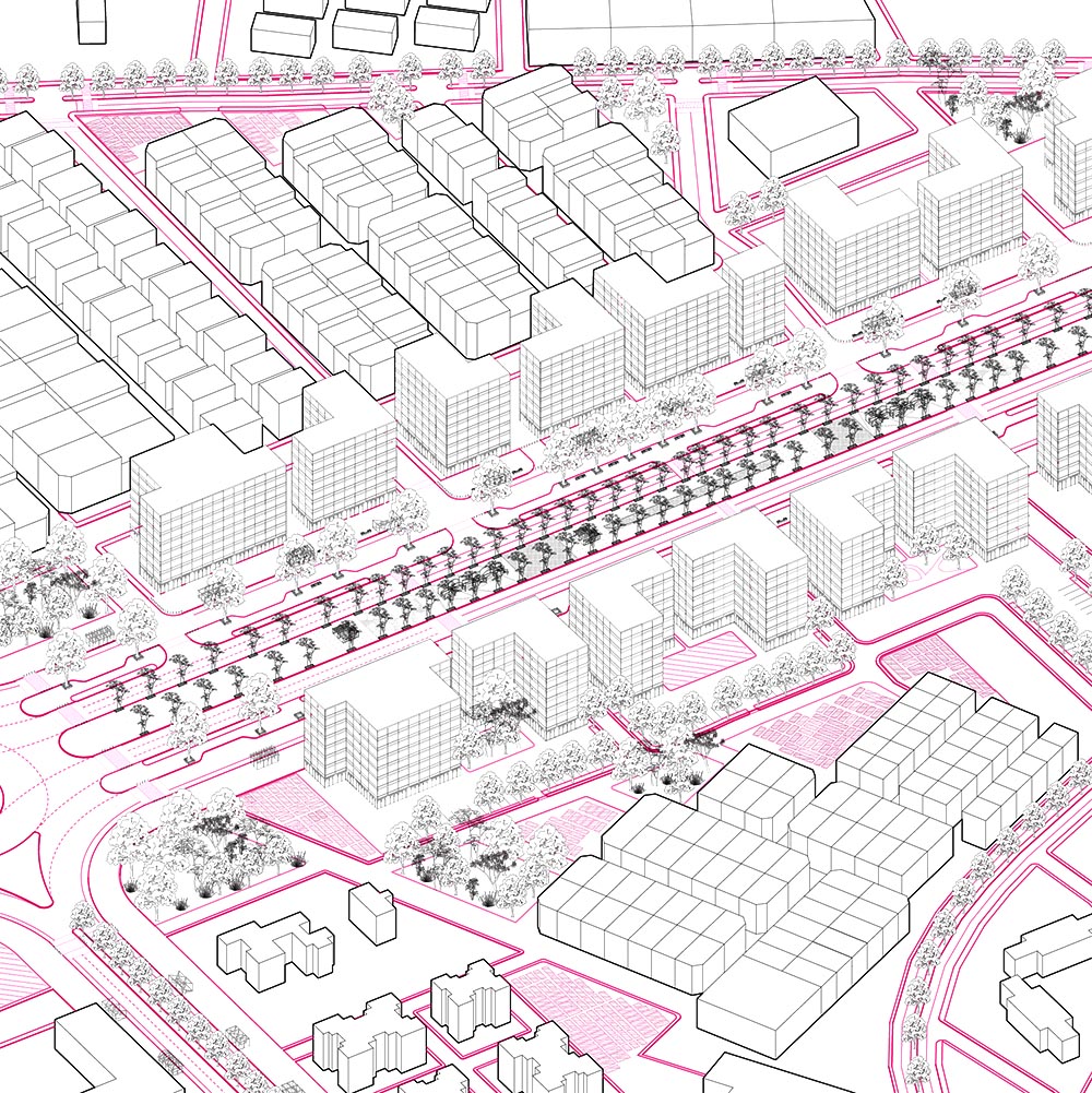
Proposed plan
As per the strategies, all the primary streets in Gandhinagar were redesigned. As each street had a distinct character of its own, to maintain a homogenous language a constant footpath of 12m has been kept. As per the ROW, the streets have been redesigned to accommodate a diaspore of activities not only along the footpath but also on the median in a few cases. Every street has a 3m bioswale that will help act as a catalyst for the biological processes to take place.
The L scale plan concentrates upon the 100m street. The median is redesigned to support a range of public activities such as markets, play zones, and gardens. Adjacent to that is the 3 lane carriageway along which the Multi-utility zone is designed which contains 3 m wide bioswales and seating and parking places. Attached to that is the service lane used to access the internal roads of the sector. The service lane also has a designated cycling track. A footpath of 12m consisting of allotment gardens has been designed. Along with that, the plots that abut the 100m street have been developed as per new built-form regulations. The plots are designed as high-rise commercial storefronts which will be built to the line so as to maximize the frontage along the footpath. The maximum permissible ground coverage is 70% with a compulsory 10% of the total plot area being dedicated to green spaces. The maximum height for the street is G+7 to G+9. Vacant lands within the vicinity of the street have been given productive uses so as to create a larger network of food production within the city.
In the zoomed-in plan, the allotment gardens are placed on the edge of the footpath. This helps the ground floor of the building to further expand on the footpath without hindering the people working in the allotment gardens. The allotment gardens accommodate various activities including food production, social spaces, and vending spaces giving the user a wide range to choose from. The users can lease out these allotments from the government to produce food and other activities.


Catalog
The catalog demonstrates the three main techniques of food production namely hydroponic farms, aquaponic farms, and greenhouse and the planting palette suggests the various kinds of vegetables, fruits, flowers, and herbs that one can grow using these techniques. Apart from that, the allotment can also be used for recreational purposes such as Seed library, musical garden, jungle gyms, etc.v


Views
The perspective view highlights the various processes that will simultaneously take place on the 100m street. The three layers of tree lines, the interconnected root system, and public activities all come together to activate the streets of Gandhinagar.
