

Coexist: Embracing the wilderness
-
Tags
Riverfront development, Public space, Biodiversity, Gandhinagar, Ecological design, wilderness, weaving with nature, sabarmati riverside, Humans and nature
Authors: Radhika Maitra
Spanning across a stretch of 1.2 km by 0.8 km by the Sabarmati river, the proposed design aims to integrate humans with the local ecology and wilderness around. A framework was developed to ideate and visualise these aims. The main focus was to create a coexistence between humans and nature.
The site was divided into upland, midland and riparian zones using a trail network to define human accessibility. The upland pollinator zone is completely accessible to humans and has the main social architectural inserts. On the other hand, the midland zone has limited human access due to high presence of diverse species, and has architectural inserts targeted towards these species.
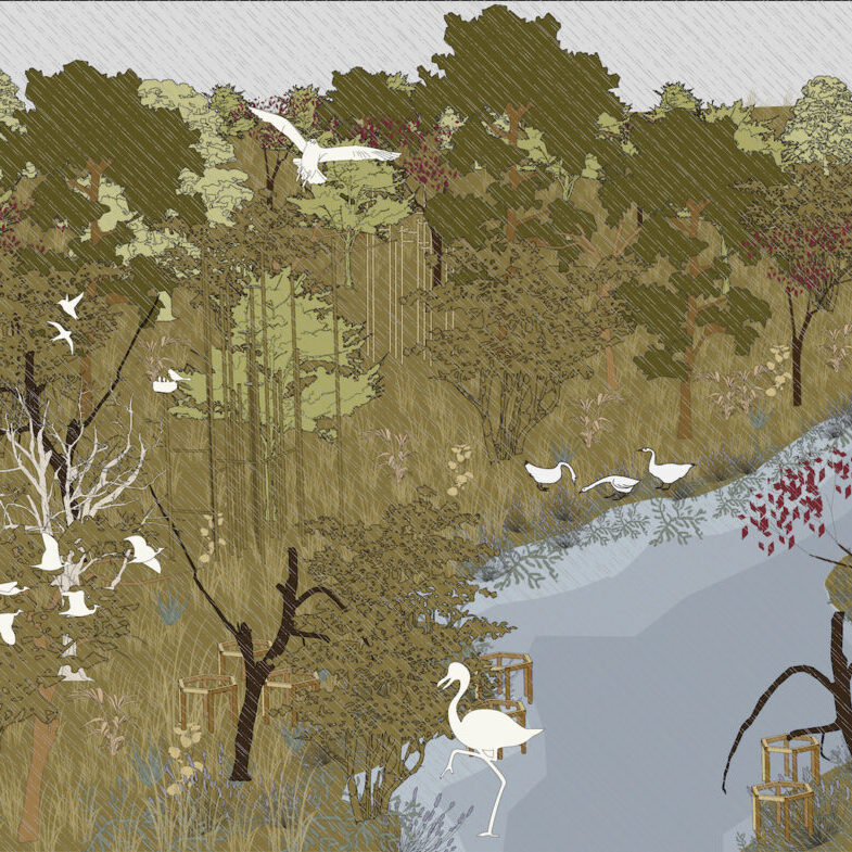
Light architectural inserts are utilised for these specified target groups, and the material used is bamboo and timber. Trails are 3 metres wide in the upland zone and 1.5 m wide in the midland and riparian zone. They end in decks on the Sabarmati, and become a way to reflect on the river & its ecology.
Understanding the Wilderness: Perceiving, Observing and Analysing the grains seen and biological diversity spotted
In Gandhinagar, the banks of Sabarmati are covered with dense wilderness that are untouched by human action to a large extent. This project begins to include this kind of space within development of the city, and connect the people living in the city to the pockets of nature around them.

Before being in the wilderness, people tend to have negative preconceived notions about it and its importance as a pocket of nature is not appreciated

On site visits, our perceptions of the wilderness were swayed too. We saw how many flora and fauna species were present in this nondescript area, and how this wilderness was a home for them.

The texturality of the wilderness was then observed through grain studies of three spots in it – upland, midland and riparian.

In doing these grain studies, flora and fauna species were also spotted and identified.

This stretch of the Sabarmati has many flora and fauna species throughout the year, especially in the monsoons. These were listed and their characteristics – heights and seasonality – was studied.
Selecting: Based on mapping the fauna spotted along the Sabarmati River, the site – Wilderness along the Central Vista opposite to Punit Van – was selected

Fauna species that were observed on multiple site visits were mapped along the banks of Sabarmati in Gandhinagar. Amongst all of the other sites, the most biological diversity was in the wilderness along the Central Vista opposite to Punit Van.
Ideating: Creating a vision plan for Gandhinagar City, incorporating the diversity of flora and fauna into the cityscape

With the vision of integrating biodiversity and the numerous non-human species around into the city, an XL Scale plan was developed. This was when the framework started forming in the design process – Respect, Restore, Rest, Reach, Reflect – and this was tied to human interaction with the non-human species around them.
Conceptualising: Developing a framework and making a concept plan for the selected site

Respect involves knowing where human intervention and access is not required. Restore involves repairing certain issues on site through human intervention. Rest delves into accessing the wilderness. Reach opens up the space for human interaction with biodiversity through activators designed for humans and non-human species. Finally, Reflect consists of ways to sum up this journey taken through the wilderness.

According to this expanded framework, a concept plan was developed for the site keeping in mind the flora and fauna species mapped. Zones were created based on human accessibility and inaccessibility, with the animal movement corridors seen kept in the inaccessible zone. Then, the activators for non-human and human species were overlaid on this plan. Finally, the planting palette was placed onto this concept plan to create pollinator, grazing and fruit-bearing zones near activators for birds and bats.
Proposing: Site Plan and Zoomed in Plans according to the activators for target groups, social spaces and planting palette

Thus, the plan for the site was developed keeping the existing ravines and contours intact. Ponds were created on existing depressions on site for amphibians and other species. The trail network divides the site into three zones – Upland, Midland and Riparian, and the accessibility of the three are very different.
The upland zone is accessible to humans due to the gentle contours and thus, the trail network is 3 m wide. Social spaces like the playground are in this zone. The midland zone is where numerous fauna and flora species thrive and this zone has limited accessibility for humans due to the steep contours. The trail network here is 1.5 m wide to limit this accessibility further. This network of trails ends in decks near the riparian zone, which also has limited accessibility for humans.

The zoomed-in plan A shows activators for birds like black drongo, lesser flamingo and kingfisher, as well as the arboreal playground for tree-dwelling fauna. These are placed near the ravine in the riparian zone since migratory birds usually nest near the river.
Zoomed-in plan B shows the pedestrian entry into the site and the social space in the upland zone. This zone has many pollinator species, and thus the planting palette followed here focuses on these species.
Zoomed-in plan C shows the entry into the site from the vehicular road. The road is lined with fruit-bearing trees to encourage foraging as a connection to nature.
Visualising the Playground: Focussing on Humans and their interaction with the wilderness

The playground within the wilderness acts as an activator for children. Nestled among trees and shrubs, the playground has ponds as well as many butterflies and amphibians. This space is designed keeping only humans and their interaction with biodiversity in mind. Thus, people are the active subject in this space and non-humans are passive.
Visualising an Observation Zone: Humans and Biodiversity observing each other

The observation zone is the space where humans and biodiversity were equally considered while designing. This falls under Reach, because both humans and biodiversity can observe each other in this space. These zones are located in the midland zone, in the presence of many flora and fauna species.
Visualising a Bird Habitat along the Ravines: Focussing on Non Humans and their interaction with the wilderness

The ravines and the riparian zone have many avifauna species that call it a home, such as the lesser flamingo, painted stork and kingfisher. The Bird Habitat has activators for the nesting of birds, and non-human species are the active subject in this space. The trail network is kept away from these bird habitat zones.

Perspectives: Looking at change in seasons and different points of view

Linking: Smaller details that tie the project together


Selecting the target groups for the design based on


Evolution of the design both on XL Scale and L Scale